Buying or refinancing an older commercial property often means working from utility records that stopped matching the site years ago. Water, sewer and storm lines may have moved with each new tenant or addition. When you order an ALTA survey, you need to know which of those private utilities the survey will actually show.
An ALTA/NSPS Land Title Survey always maps the utility evidence a surveyor can see on the site. Buried private lines with no surface clue only appear when the scope adds client records or a private utility locate. On older commercial properties, that difference can shape a deal or a building plan. It’s worth settling the scope before fieldwork starts.
Why Private Utilities Can Be Hard to Verify on Older Sites
Private utilities get hard to verify when years of changes outrun the records. A private utility is a line the property owner owns and maintains instead of the utility company. On a commercial site, that might mean the water service past the meter, the sewer lateral out to the public main, storm pipes under the parking lot or wiring for pole lights and signs.
Many older commercial properties have changed a lot over the years. A shopping strip may have split one store into three units. A warehouse may have gained an office wing or a second loading dock. Each change could add a new line or leave a dead pipe in the ground. The plans in the owner’s file often show the first design and none of the later work.
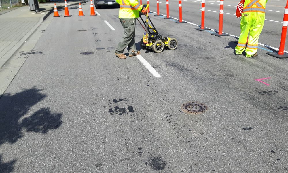
Maryland’s one-call system adds another wrinkle. Miss Utility notifies member utility companies before digging, and those members mark their own lines. They don’t mark privately owned underground lines, and Miss Utility tells owners to hire a private locating company for those. A site can show fresh paint for the gas main in the street and no marks at all for the sewer line behind the building.
Which Utility Evidence Can Appear on an ALTA Survey
An ALTA survey always shows the utility evidence the surveyor observes on the ground. The 2026 ALTA/NSPS standards took effect on February 23, 2026, and they keep this as a base requirement in Section 5.E.iv. You get it whether or not you add any optional items.
Observed evidence means things a field crew can see. Manholes, cleanouts, valve boxes, meters, catch basins, transformers and light poles all count. Paint or flags left from an earlier locate can count too. A sewer cleanout by the back door tells the surveyor a line exists. It doesn’t reveal the full path of the pipe under the pavement.
Most confusion about the utilities shown on an ALTA survey comes from the split between required and optional work. Table A is the list of optional items a client can add to an ALTA survey. Item 11 adds underground utility evidence from one or both of two sources. Under 11(a), the surveyor shows lines from plans or reports the client provides and notes where each came from. Under 11(b), a private locator marks lines on the ground and the surveyor maps those marks. Either way, the surveyor combines that information with the observed evidence on one drawing.
When Utility Records Need More Than Field Evidence
Field evidence stops where a pipe leaves no mark on the surface. A storm line under asphalt or an old water line cut off during a remodel may have no structure above it. The surveyor can’t map what nobody can see. Records and locates have to fill that gap.
Useful records include site plans, as-built drawings, permit drawings, older surveys and any utility agreements tied to the property. Older plans need some caution. They often show what a designer intended, and the contractor may have built something different. The surveyor notes where record information came from so readers can judge how much to trust it.
A private locate has limits too. Locating equipment does well with metal pipe and lines that carry a tracer wire. Plastic pipe without tracer wire can be hard to find. Locate marks show where a line runs across the ground, and they usually don’t show depth. If a design team needs depths or pipe inverts (the inside bottom of a pipe), that work may call for a separate scope, such as measuring inside structures or digging test holes.
How Utility Information Affects Commercial Site Decisions
Private utility locations shape where you can build, dig or pave. A planned addition might sit right on top of the sewer lateral. A new parking area might cut across the storm line that drains the roof. Spotting these conflicts on the survey gives the design team time to move a footprint or plan a reroute.
Utility details matter during due diligence as well. A lender or title company may want to see lines that cross onto a neighbor’s parcel or serve another building. A shared private line between two pad sites can raise questions about who maintains it and whether an easement covers it. The surveyor maps the line, and an attorney or title professional handles the ownership side.
Gaps cost the most when they show up late. A crew that hits an unmapped line during excavation may have to stop work and wait on a redesign. Knowing about the uncertainty early lets a buyer price that risk or add a locate before closing.
What to Request Before Ordering the Commercial ALTA Survey
Start with what you plan to do with the property. A buyer keeping the building as it stands may only need the observed evidence every ALTA survey includes. A buyer planning an addition, new paving or a utility upgrade will likely want more. Share that plan with the surveyor up front so the scope fits the work.
Before you sign the survey contract, cover these points with the surveyor and your project team:
- Old site plans, as-builts, permits and prior surveys you can hand over
- Whether Table A Item 11 fits the project, and which source makes sense
- Who will hire and schedule a private locator, since the 2026 standards let either the surveyor or the client coordinate it
- Whether the design team needs depths or inverts beyond what the ALTA will show
- Any lender or title company requirements for the survey scope
Ask how the drawing will label each source of utility information. Clear notes tell everyone later which lines came from field evidence and which came from records or a locate. Those notes stay useful after closing, too, when the next project on the site gets started.
Frequently Asked Questions
Can an ALTA survey show a privately owned sewer or water line?
Yes, at least in part. The survey shows the visible pieces of the line, such as a cleanout, meter or valve box. To show the full underground route, the scope usually needs Table A Item 11 with client plans, a private locate or both.
Does an ALTA survey guarantee every underground utility is located?
No. The survey maps visible evidence plus whatever sources the client added under Item 11. Some lines leave no surface clue and some records turn out wrong. Maryland still requires a Miss Utility request before anyone digs, even with a finished survey in hand.
Should old utility plans be provided to the land surveyor?
Yes, share whatever you have. Under Item 11(a), the surveyor can show lines from client plans and cite their source on the drawing. Even without Item 11, old drawings help the field crew know where to look for covers and structures. Point out any plans you suspect are outdated.